Regional wildfire update
Here’s an update on fires burning in our region.

Elephant Fire
Not a CalFire incident, but CalFire reports the fire has burned 13,401 acres and is 31 percent contained.
According to InciWeb at 9:43 p.m. last night, “Firefighters in the northeast portion of the fire focused on securing the dozer line where defensive firing operations took place. With the successful completion of this operation, firefighters will now begin to secure the fireline with mop-up and direct suppression tactics, increasing containment. Aircraft remains available to cool remaining pockets of heat, if needed.
“Both acres burned and containment decreased due to improved mapping, which more accurately represents the burned and unburned Firefighters continue to make steady progress on the Loomis Fire. Last night, an infrared mapping aircraft flew over the fire to identify remaining areas of heat. The infrared imagery is helping firefighters pinpoint hot spots so crews can focus suppression efforts in those locations today.
Personnel are also continuing to strengthen and improve containment lines while making good, black line around the fire perimeter to further secure the incident and increase overall containment.
portions of the interior of the fire. With unburned islands excluded from the overall acreage, the amount of perimeter to be contained has grown. For more information on how acres burned and containment are assessed, refer to NMAC Correspondence L2026-06 at nifc.gov/nicc/nmac.”

3-1 Pit Fire
According to CalFire the 3-1 Pit Fire has consumed 1.055 acres and is 95 percent contained.
At 8:01 a.m. this morning, CalFire reported, “Fire personnel continue to make steady progress on the 3-1 Pit Fire. Crews are completing fire suppression repair operations throughout the incident while focusing on extinguishing the remaining hot spots located within the Pit River Canyon.
“The final hot spots are in extremely steep, rocky, and rugged terrain, making access challenging and requiring firefighters to work carefully and methodically. Crews will remain in the area until all remaining heat has been fully extinguished and suppression repair activities are complete.”
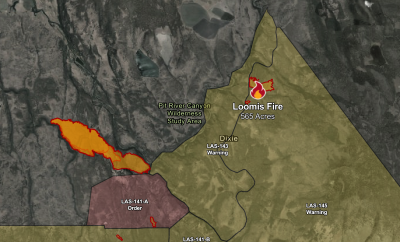
Loomis Fire
According to CalFire, the Loomis Fire has blacked 656 acres and is 45 percent contained.
At 8:02 a.m. this morning, CalFire reported, “Firefighters continue to make steady progress on the Loomis Fire. Last night, an infrared mapping aircraft flew over the fire to identify remaining areas of heat. The infrared imagery is helping firefighters pinpoint hot spots so crews can focus suppression efforts in those locations today.
Personnel are also continuing to strengthen and improve containment lines while making good, black line around the fire perimeter to further secure the incident and increase overall containment.

Twain Fire
According to a statement by the U.S. Forest Service, “Firefighters are continuing to make good progress on the Twain Fire, located on the Plumas National Forest north of California State Highway 70 in the Feather River Canyon.
“Despite conditions being hot and dry today, with temperatures in the upper 90s, firefighters are reporting approximately 75 percent containment this evening.
“The fire is holding at 276 acres. Firefighters are continuing to work on securing fireline and mop up.
“Traffic controls in the area on Highway 70 will lift tonight. However, they are expected to be in place during daytime hours Thursday through Saturday due to safety concerns, including rolling debris as firefighters work to control the fire above the highway and heavy firefighter traffic.
“Plumas National Forest Fire and incident leadership appreciate Caltrans District 2 leadership and employees for providing 24-hour traffic controls since the fire was reported last Saturday. This was critical for firefighter and public safety.
“Area residents and visitors should watch for increased firefighting traffic area, especially in the morning and evening. It’s advised to reduce speed and be prepared to slow down for firefighting equipment entering and exiting the highway in the area around Twain.
“While fuels are continuing to burn within the firelines, there is less smoke being produced and smoke impacts are light on the highway and in nearby communities.
“The Pacific Crest Trail is open and there are no significant impacts from the fire. Hikers may experience some light, short duration smoke.
“The cause of the fire is under investigation.
“Fuels on the Plumas National Forest are very dry and wildfires can grow quickly, especially with hot temperatures and afternoon winds. Area residents and visitors are asked to be careful with anything that can spark a wildfire and to help prevent additional fires. The public can also report suspected wildfires by calling 911.”
For more information on the Plumas National Forest, visit fs.usda.gov/plumas or on Facebook at facebook.com/USFSPlumas.